The geography of ancient Greece played a massive role in the development of city-states.
Ancient Greece was never a united country except for under the reign of Alexander the Great.
Natural barriers like mountains, the sea, and hundreds of islands aided in the formation of the city-states and these natural barriers led the ancient Greek people to occupy lands closer to the coastline.
Overall, the geography of ancient Greece is divided up into three geographical formations which include the lowlands, the mountains, and the coastline.
Each of these regions provided something needed for a civilization to thrive.
The mountains supplied fresh water, the seas fish to eat, and the lowlands allowed for farming.
The Mountains
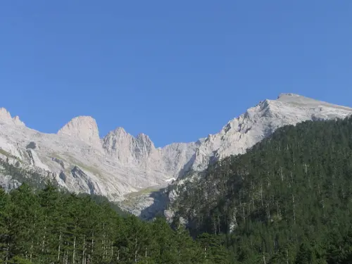
The mountains in ancient Greece are not like the Alps and account for 80% of the land mass.
The main mountain chain in ancient Greece is the Pindus Mountain Range. This mountain range flows north to south through most of mainland Greece.
The mountains provided two important factors in the development of city-states.
The first is fresh water. Every civilization relies on fresh water.
Fresh water flowed down the mountains in creeks and streams and city-states began to sprout up next to these sources of fresh water.
Transportation along the rivers and creeks in ancient Greek was nonexistent because the fresh water systems dried up in the summer and swelled in the winter time.
The fresh water systems also gave life to cattle and sheep with the thousands of shrubs for them to eat along the creeks and rivers.
The second factor mountains provided city-states was a natural defense barrier.
The development of individual city-states in ancient Greece was aided by the mountainous terrain which made road building difficult.
Without an extensive road system the city-states were isolated with the help of the mountainous terrain.
The mountains in ancient Greece played an important role in religion and the ancient Greek gods.
The Olympian gods lived on top of Mount Olympus, the highest point in Greece.
Because of the gods, city-states built temples and their palaces on mountain tops such as the Acropolis in Athens.
The Coastline
The ancient Greek peninsula was surrounded by a lot of saltwater and the coastlines were dotted with hundreds of islands.AdvertisementAdvertisementAdvertisement
There were also numerous smaller peninsulas along the coastline which were ideal natural harbors.
The hundreds of city-states relied heavily on the seas for transportation.
Ancient Greeks learned to sail and travel the coastal waterways in order to trade goods or fight with a neighboring city-state.
The population in ancient Greece also needed to eat.
There were small pockets of farmable land along the coastline but not much for a growing population.
Instead the coastal waterways supplied plenty of fish and waterfowl for the ancient Greeks to eat.

Ionian, Aegean, and Mediterranean Seas
Within these three seas there are thousands of islands of which many were occupied by the ancient Greeks.
The isolation of an island by the surrounding sea also contributed to formation of city-states.
The largest island was Crete. Other important islands included Chios, Delos, and Rhodes.
The Lowlands
The lowlands in ancient Greek contained about 20% of farmable land.
Farmers cultivated numerous crops like olives, grapes, wheat, and barley.
Crops were limited because of the climate.
The climate in ancient Greece brought hot and dry summers.
During the winter the climate was windy, mild, and wet.
The ancient Greeks relied on trading goods and importing goods from various regions surrounding the Mediterranean, Aegean, and Ionian Seas.
The lack of farmable land in ancient Greece led to the spread of ancient Greek culture too.
The ancient Greeks wanted control the trade of grains and foods. This led to the ancient Greeks setting up colonies in Asia and North Africa.
Regions within ancient Greece
The natural geographical formations of ancient Greece helped form three distinct regions-the Peloponnese, Central Greece, and Northern Greece.
The Peloponnese is situated on the southernmost area of the peninsula. It is attached to central Greece by a small strip of land called the Isthmus of Corinth. This region was home to several important city-states including Sparta, Argos, and Corinth.
Central Greece lies north of the Peloponnese. The region includes Attica which connects with the Isthmus of Corinth. Major cities included Athens and Thebes.
The northern Greece region is usually thought of as three areas which are Macedonia, Thessaly, and Epirus. Mount Olympus is also located in this region of ancient Greece.
Outside settlements
The ancient Greeks formed several settlements within the Mediterranean Region. They were formed to support trade and supply food to various city-states. There were colonies located in modern-day areas of Spain, North Africa, France, and Turkey. With more colonies in the region, ancient Greek culture spread rapidly throughout the area.
Facts about Geography of Greece
- The Pindus Mountain Range is referred to as “the spine of Greece”.
- With a lack of farmable land, ancient Greeks formed colonies around the Mediterranean Region to supply grains and food.
- Alexander the Great was born in Macedonia in northern Greece.
- Summers were hot and dry. People wore little clothing during this time of year. Winters were windy, wet, and mild forcing people to wear cloaks ad wraps around the necks.
- The Aegean Sea has nearly 1,000 islands.
- Crete is the largest island in ancient Greece.
- The geography of ancient Greece played an important role in the development of independent city-states.
- Ancient Greeks worshipped the twelve Olympian gods who lived atop Mount Olympus in northern Greece. The ancient Greeks built numerous temples on hills and mountain tops such as the Acropolis in Athens.
FAQ’s
How did the geography of ancient Greece help develop the city-states?
The geography of ancient Greece provided natural barriers which aided in the development of independent city-states. There were few roads connecting city-states and they traveled mainly by waterways on the Ionian, Aegean, and Mediterranean Seas.
What are the prominent geographical formations of ancient Greece?
The main geographical formations included mountains, lowlands, coastal land, and the three surrounding seas where thousands of islands are located.
What mountain range exists in ancient Greece?
The Pindus Mountain Range runs north to south along most of mainland Greece. The mountains provided an excellent natural barrier which helped city-states form. Streams and rivers flowing down from the mountains also provided much needed fresh water. Mount Olympus is the tallest mountain in Greece.
What was the climate like in ancient Greece?
The climate in ancient Greece brought hot and dry summers. Winter time was wet, windy, and mild.
Why was the geography of ancient Greece important?
The geography of ancient Greece provided natural barriers such as mountains, coastland, and islands which aided in the formation of independent city-states.
What did you learn?
- What is the name of the tallest mountain in ancient Greece?
Mount Olympus
- In which region was the city-state of Athens located?
Central Greece
- What three seas surround the ancient Greek peninsula?
Aegean, Ionian, and Mediterranean Seas
- What ratio of land mass in ancient Greece is covered with mountains?
80%
- What geographic formation connects the Peloponnese and Central Greece?
Isthmus of Corinth
